Friday, April 29, 2011

Puerto Rico - Arriving on the West Coast

I'm falling behind in my blogs so in the next few postings I'm going to try to cover a lot of ground, so to speak.

On arriving in Puerto Rico, I found I liked it immediately. The rich green rolling hills climbing towards the volcanic peaks in the eastern half of the island was a great contrast to the flat landscape of Florida, The Bahamas, and the Turks and Caicos. The people were also very welcoming, as I worked out how to clear in.

Being a US Territory, clearing in to Puerto Rico for a US Citizen is pretty straight forward. However, if you don't participate in the US Customs Local Boater system, it's less convenient than most Carribbean ports of call. US Customs is located downtown in Mayaguez, about 15 miles north of Puerto Real. We chose not to stop in Mayaquez to clear in because it is a commercial port and not very comfortable for small vessels like Mirasol. Instead, the procedure is to call an 800 number on arrival and provide your information over the phone. I tried to do this with my satellite phone, but the phone system wouldn't accept an international call into the 800 number.

A local saw me trying to call customs and offered his cell phone for my use. He introduced himself as Fernando from Salinas and ran a small convenience shop in the marina complex. He proved to be an excellent source of local info, anchorage recommendations for the western and southern coasts of Puerto Rico, and best of all, $0.93 ice cold beers. I asked him where I could find a good chart for the anchorages he mentioned, and he dug out an old marked-up chart and gave it to me.

Anyway, back to clearing in. Customs took down our passport and vessel information over the phone and then told us we had 24 hours to present ourselves at the Customs office in Mayaguez to complete the process. The president of the marina, Jose, arranged for a car to take us the 15 miles up the coast to the Customs office. We were cleared in without any hassle and also signed up for the Local Boater program to avoid having to present ourselves in person in certain US ports in the future.

On the way back to Puerto Real, the driver stopped at a grocery store and we loaded up on groceries, and a little local rum and beer.

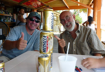
Speaking of the local rum and beer... Don Q is the local rum, and I find it the best silver rum I've tasted, certainly better than Bacardi Silver. The local beer favorite is Medalla, pronounced Mediiya, and it also quickly became a favorite on board. It is served in 10 oz ice cold cans, often so cold ice is frozen to the side of the can. When I first arrived in the Caribbean last year I found that 10oz cans and bottles are commonplace, and as we approached the summer months the reason for this is evident. It can be HOT here, especially if you're sheltered from the trade winds. You will want your beer ICE cold. The smaller 10oz cans are easy to finish off before that last bit gets warm. At $1 a beer, I can live with the smaller can. As I will be reminded later in our voyage, the smaller can doesn't come with a corresponding smaller price tag as you move south down-island. But that's for another blog.

I suppose I didn't cover much ground in this post. I'll do better in the next, or I'll never catch up! (We’re in the BVI as I write this).

Monday, April 18, 2011

Turks and Caicos to Puerto Rico

We left the sheltered water of the TCI banks for deep water around sunset on Wednesday, March 23rd. We had waited two weeks for this window and were eager to go. The weather window was a little shorter than we wanted, but with the winter cold fronts becoming rare, we took what we could get. It turned out to be a challenging but rewarding 462 nautical mile passage

As anticipated, we were motoring into a fairly steep 6-8 foot swell accompanied by 3-4 foot wind waves. The winds had been blowing 20-25 knots on Tuesday, were now 15 knots, and was supposed to continue to diminish. While motoring into these wind and wave conditions is unpleasant, it was necessary to set us up for a few days of light south easterly winds in which we could make our way east to Puerto Rico. Normally, the Trade Winds would be blowing 20 knots out of the east, making this run impossible, or at least extremely miserable.

The wind and wave conditions did not diminish as quickly as we had hoped. About 18 hours into the passage our friends on Oceana decided to divert south to the Dominican Republic. The opposing wind and waves were chewing up their fuel, putting Puerto Rico out of their range. They turned south on a comfortable beam reach sail to Puerto Plata, DR, and arrived safely the next day.

Mirasol was also burning fuel at a high rate, but we were confident we could make it stretch to Puerto Rico by sailing due east rather than heading directly for Puerto Rico. This kept us from heading straight into the southeast winds and seas, and set us up for a fast beam reach sail due south once we reached Puerto Rico's longitude.

By mid day Thursday Jen and Quinn were both dealing with cases of mal de mare and the wind and seas had refused to lay down. When the trades winds were finally stalled by the cold front just north of us, we continued motorsailing due east in more comfort. We were motoring with one engine and a full main to conserve fuel, but we were fighting a 1.5 current so we were only making about 3.5 knots. We gave up on any hope of a Saturday arrival and figured on mid-day Sunday.

On Friday evening we were 200 miles due north of Puerto Rico's west coast. It was finally time to turn south. We put the helm over, rolled out the jib and shut off the engine. We were a sailboat at once again. Friday night and Saturday we enjoyed ideal sailing conditions with gentle seas and the wind on the beam. By midnight on Saturday, we were well into the Mona Passage between the Dominican Republic and Puerto Rico.

We discussed risking a night time arrival, but in spite of our eagerness to complete the voyage, we fell back on our rule of avoiding unfamiliar landfalls at night. To set up a dawn arrival in Puerto Real, Puerto Rico, we ghosted along on a furled jib and no main through the rest of the night. We entered Puerto Real's picturesque harbor as the sun broke over the hills. It was one of our prettiest landfalls. After the sparse vegetation and arid terrain of the Bahamas and the Turks And Caicos, the lush, mountainous vistas of Puerto Rico were amazing.

This was our most challenging passage to windward, and we were happy to have it behind us! Jen took this picture of Quinn and I as we approached the west coast of Puerto Rico. A tired but happy crew.


Turks and Caicos Islands, March 2011

We spent 14 lazy days in the Turks and Caicos. After spending time in the Exumas and other out islands of the Bahamas we were ready for some access to grocery stores, restaurants, laundry, barber shops and other niceties of civilization. Accordingly, we chose to spend the time in a marina. The anchorages were all quite remote from any towns or facilities.

We made South Side Marina on Providenciales Island our home for those two weeks, and had a very enjoyable time. While on the dock we took several excursions to the touristy side of town. Our first night on Provo, Jen and I had a delightful dinner in a wine bar while Kathy and John Reager from Oceana watched Quinn for us. Another memorable excursion found Jen, Quinn and I on a day-long walk along the Grace Bay Beach, checking out all the beachside resorts. Jen and I were very impressed with the beach, as it was miles long, clean, and protected from the big ocean swells by a barrier reef about a mile out. Snorkeling, diving, windsurfing, tube rides, parasail rides, and catamaran booze cruises were among the many activities available. Anyone looking for a fun beach getaway should consider Provo's Grace Bay in the Turks and Caicos!

The diving here is quite good, and I did two dives off of West Caicos island. They were both wall dives and were a lot of fun. The most interesting thing was seeing barrel sponge coral spawning. They were all doing it at once, which is something to see. Imagine large smoke pots as the spores swirled up and out of the huge barrel sponges in reddish-brown clouds. I've never seen anything like it before. We also saw three large sharks cruising the wall, a few barraccuda, plenty of coral and reef fish plus the usual critters. The dropoff was spectacular as it dropped from about 50'to 3000' straight down. Now that is a wall dive!

It was a bit of a walk to town from the marina, but the marina staff were happy to provide a ride when they had time available. The ride was a pickup truck and was in high demand by the other boats in the marina, so we were usually in the back hanging on. Riding in the back of a pickup truck is old hat for Jen and I (thanks for all those rides in high school, Matt) and Quinn loved it.

Every evening at 5:00 the marina organized a happy hour where everyone would gather with sundowners, substancial appetizers and plenty of stories to share with the other cruisers. The Turks and Caicos is a hub for cruisers heading either north or south at this time of year, so we met several cruisers who were also heading for the Windward Islands for the rest of the season and a few working their way back north.

There actually was some work accomplished during our stay. I took care of a lot of mainenance items while we had the convienience of a marina. Propane refills, engine oil changes, fuel filter changes, water maker maintenance, and general upkeep items. Jen did some serious spring cleaning, tons of laundry and knocked off several pages of scrapbooking.

Other cruisers had more serious maintenance issues. Our friends on Oceana have a substancial stainless steel davit assembly on the stern which supports two large solar panels as well as their dinghy. Two key support welds had failed requiring attention from a local welder to put right. A Lagoon 380, Lucy, arrived missing one propeller. Appearantly one of theirs fell off in transit from down island. Go figure. The replacement prop arrived via Fed Ex, but the custom cone nut did not. After several days of trying to track down the missing shipment, Lucy's captain lost patience, stated that Lucy was a sailboat after all, and resumed their voyage to Ft. Lauderdale with one engine missing a prop.

One day I was determined to walk to town. I had an errand to run and needed the exercise after all those happy hour appetizers. I took Quinn with me and we settled into the walk. We had made it only about half way before a local stopped to give us a ride. When dropping us at the store they asked us if we wanted their number to call if we ever needed another ride. Same thing on the way back: we weren't half way home when a car stopped to give us a ride and we were again offered a phone number. Nice folks here.

After about a week in the TCI we were ready to move on, but we needed a good weather window to beat 400 miles southeast against the trades. On the 14th day it arrived (sort of), and we were off to Puerto Rico.

Saturday, April 2, 2011

The Thorny Path

Travelling by sailboat from Florida to the Leeward Islands of the Caribbean is called the "thorny path" to the Caribbean. It has this name because it entails travelling about 950 miles southeast straight into the trade winds. That is a long, long way to go upwind.

One way to do this is the offshore route. You depart Florida, swing north of the Bahamas and head east until you are due north of the Virgin Islands. Once you have made your easting, you can turn south and enjoy a beam reach into the Virgin Islands. Since you're already quite far south, most of this trip requires beating into the upper edges of the trade winds to make your way east.

If you have the time, a more enjoyable (and marriage-preserving) route is to island hop. You make your way through the Bahamas, take a short passage to the Turks and Caicos, and then a longer one to Puerto Rico, sometimes via the Dominican Republic. Once in Puerto Rico, you have short day sails as you coast along the south side of Puerto Rico and on into the Virgin Islands. It sounds straight forward, but there are a few prickly thorns in that route as well.
The first part of the journey is pretty easy, and only requires one or two overnight passages. We sailed from Miami to Bimini, then on to the Exumas where we spent a fair amount of time. From the Exumas we sailed to Rum Cay, in the out islands of the Bahamas.

Once you get as far south as Rum Cay, you have dipped your toe into the trade winds, which blow with remarkable consistency from the East. At the same time, you are leaving behind the many sheltered anchorages of the Bahamas, and the short daylight passages they provide. Ahead of you lay larger stretches of open ocean.

The solution is to take advantage of cold fronts rolling off of the southeast coast of the US that tend to stall just south east of the Bahamas. These cold fronts tend to shut down the trade winds between the Bahamas and the Virgins, providing a weather window in which you can motor or motor-sail to the next staging anchorage in light easterly winds. If you time it right, you can enjoy gentle rollers, light easterly winds of under 15 knots and wind waves under 3 feet on the nose. Without these windows, you are faced with head winds over 20 knots and steep eight foot or more seas on the nose. A recipe for broken boats and very unhappy crew (meaning, a furious wife).

Our passage from Rum Cay to the Turks and Caicos was our first leg in this difficult portion of the Thorny Path. We left Rum Cay after a whopper of a cold front blew through. There were 8-10 foot rollers on our beam, but they were gentle and spread out. The wind and associated wind waves had laid down and we had a pleasant first half of the passage. By midnight, however, the wind picked up on our nose and we ended up pounding for several hours until we found ourselves in the lee of the Turks and Caicos. We probably would have waited a few days for a longer window, but we were very eager to catch up with our friends on Oceana, who were already in the Turks and Caicos.

The entrance to the Caicos Bank is a 200 foot wide cut called the Sand Bore Channel. It is the only access to the well protected Caicos Bank from the west. Passing through the channel, we left behind the deep blue ocean and found ourselves in 10 feet of beautiful turquoise water as far as the eye could see. It was an astounding change.

The Turks and Caicos are a part of the British Commonwealth and are located south east of the Bahamas and about 80 miles due north of Hispaniola (Haiti and the Dominican Republic). The Caicos islands and cays surround the Caicos Bank, which is a very flat plateau resting about 3 to 15 feet below the water and is sprinkled very liberally with coral heads and shoals. The Turks lie 50 miles to the east of the Caicos Islands, separated by ocean water over a mile deep.

We were excited to be in the Turks and Caicos. Friends, miles of beaches, and world renowned diving awaited us.